")
")


Difficulté

The almost vertical kilometre of the Caroux!
Steps, steps and steps that will allow you to rise quickly. After the warm-up at the start of the Tourist Office and the crossing of the passerelle des soupirs, the climb is tough...
After the col de Bartouyre (hill 680) there is a small flat respite of 300 metres and a lighter slope after the crossroads of the piste des Biterrois.
RECOMMENDATIONS
BEFORE YOU LEAVE:
> Check the weather forecast.
> Find out about the state of the route.
> Inform someone close to you about your itinerary and the planned times.
> Take water and food.
ON THE ROUTES, PLEASE:
> Stay on the marked paths for your safety and to preserve the vegetation. Do not cut the laces.
> Respect the natural environment and the properties crossed; close the barriers.
> Respect the highway code, which applies to all sections of the route that use public roads.
> Don't litter and keep your rubbish with you.
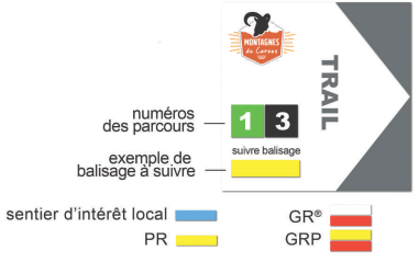
MARKINGS:
The courses are equipped with specific trail markers. Follow the course number indicated on the marker. Between two trail markers, follow the existing hiking markers: